Bolivia Volcanoes
-
Parinacota
-
Parinacota
-

Parinacota
-
Parinacota
-

Tata Sabaya
-
Licancabur
-

Licancabur
-

Tata Sabaya
-
Parinacota
-

Guayaques
-
Tata Sabaya
-
Licancabur
-
Tata Sabaya
-
Sairecabur
-
Tata Sabaya
-
Tata Sabaya
-
Parinacota
-
Parinacota
-
Parinacota
-
Tata Sabaya
Bolivia has 7 Holocene volcanoes. Note that as a scientific organization we provide these listings for informational purposes only, with no international legal or policy implications. Volcanoes will be included on this list if they are within the boundaries of a country, on a shared boundary or area, in a remote territory, or within a maritime Exclusive Economic Zone. Bolded volcanoes have erupted within the past 20 years. Suggestions and data updates are always welcome ().
| Volcano Name | Location | Last Eruption | Primary Volcano Type |
|---|---|---|---|
| Guayaques | Northern Chile-Bolivia | Unknown - Evidence Credible | Lava dome(s) |
| Irruputuncu | Northern Chile-Bolivia | 1995 CE | Stratovolcano |
| Licancabur | Northern Chile-Bolivia | Unknown - Evidence Credible | Stratovolcano |
| Olca-Paruma | Northern Chile-Bolivia | Unknown - Eruption Observed | Stratovolcano(es) |
| Parinacota | Northern Chile-Bolivia | 290 CE | Stratovolcano |
| Sairecabur | Northern Chile-Bolivia | Unknown - Evidence Credible | Stratovolcano(es) |
| Tata Sabaya | Bolivia | Unknown - Evidence Credible | Stratovolcano |
Chronological listing of known Holocene eruptions (confirmed or uncertain) from volcanoes in Bolivia. Bolded eruptions indicate continuing activity.
| Volcano Name | Start Date | Stop Date | Certainty | VEI | Evidence |
|---|---|---|---|---|---|
| Irruputuncu | 1995 Sep 1 | 1995 Sep 26 | Confirmed | 2 | Observations: Reported |
| Irruputuncu | [1989 Dec 16 ± 15 days] | [Unknown] | Uncertain | ||
| Ollague | [1903 Dec 8] | [Unknown] | Uncertain | ||
| Olca-Paruma | [1865] | [1867] | Uncertain | ||
| Parinacota | 0290 ± 300 years | Unknown | Confirmed | 0 | Isotopic: Cosmic Ray Exposure |
| Parinacota | 0090 ± 50 years | Unknown | Confirmed | Correlation: Anthropology | |
| Parinacota | 1100 BCE ± 500 years | Unknown | Confirmed | Isotopic: Cosmic Ray Exposure | |
| Parinacota | 4320 BCE ± 1200 years | Unknown | Confirmed | Isotopic: Cosmic Ray Exposure | |
| Parinacota | 5840 BCE ± 50 years | Unknown | Confirmed | Isotopic: 14C (uncalibrated) | |
| Parinacota | 7950 BCE | Unknown | Confirmed | Isotopic: Ar/Ar |
Bolivia has 22 Pleistocene volcanoes. Note that as a scientific organization we provide these listings for informational purposes only, with no international legal or policy implications. Volcanoes will be included on this list if they are within the boundaries of a country, on a shared boundary or area, in a remote territory, or within a maritime Exclusive Economic Zone. Suggestions and data updates are always welcome ().
| Volcano Name | Location | Primary Volcano Type |
|---|---|---|
| Acotango | Northern Chile-Bolivia border | Stratovolcano(es) |
| Nevado Anallajsi | Bolivia | Stratovolcano |
| Cerro Chascon | Bolivia | Lava dome |
| Escala | Bolivia | Lava dome |
| Inacalari | Northern Chile, Bolivia and Argentina | Stratovolcano |
| Jatun Mundo Quri Warani | Bolivia | Lava dome(s) |
| Laguna Jayu Khota | Bolivia | Maar(s) |
| Jorcada | Bolivia | Stratovolcano |
| Volcan Linzor | Northern Chile-Bolivia border | Stratovolcano |
| Cerro Moiro | Bolivia | Pyroclastic cone |
| Ollague | Northern Chile-Bolivia | Stratovolcano |
| Pampa Luxsar | Bolivia | Volcanic field |
| Patilla Pata | Bolivia | Stratovolcano |
| Cerro Pucara | Bolivia | Volcanic field |
| Quetena | Bolivia | Fissure vent |
| Rochaculla-Inca Camacha | Bolivia | Stratovolcano(es) |
| Nevado del Sajama | Bolivia | Stratovolcano |
| Cerro San Agustin | Bolivia | Stratovolcano |
| Sunequera | Bolivia | Shield |
| Tambo Quemado | Bolivia | Shield(pyroclastic) |
| Cerros de Tocorpuri | Northern Chile-Bolivia border | Stratovolcano |
| Uturuncu | Bolivia | Stratovolcano |
There are 44 photos available for volcanoes in Bolivia.
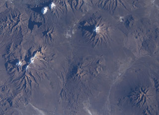
 A long E-W-trending volcanic chain extends across the border between Chile and Bolivia in this NASA International Space Station image (with north to the upper right). The chain extends from historically active Isluga volcano (upper left) to eroded Saxani volcano at the lower right. The smaller volcano immediately to the west of Saxani with a sharp shadow is the steep-sided Tata Sabaya volcano. Tata Sabaya was the source of a major debris-avalanche deposit (bottom center) that forms the small dark-colored hills on the white floor of Salar de Coipasa.
NASA International Space Station image ISS009-E-6849, 2004 (http://eol.jsc.nasa.gov/).
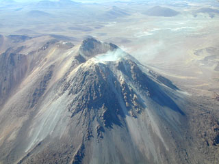
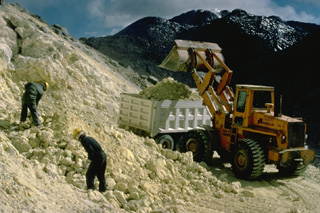 An active sulfur mine is located north of Cerro Sairecabur volcano. This chain of volcanoes along the Chile-Bolivia border contains at least 10 postglacial centers. The highest peak, Sairecabur, is located at the northern margin of a 4.5-km-wide caldera. Postglacial activity began south of the summit, but most recently produced a pristine lava flow to the NW. Escalante, at the northern end of the chain, has a crater lake at its summit and youthful lava flows on its flanks. Other eruptive centers have also produced Holocene lava flows.
Copyrighted photo by Katia and Maurice Krafft, 1983.
 The symmetrical Licancabur stratovolcano (left) rises above a basement of rhyodacitic ignimbrites and dacitic lava domes. A small 80-m-wide lake, one of the world's highest, occupies its 400-m-wide summit crater. Archaeological ruins were found on the 5916-m-high crater rim of Volcán Lincancabur. Young lava flows with prominent levees extend up to 6 km down the NW-to-SW flanks of the volcano.
Photo by Oscar González-Ferrán (University of Chile).
 Cerro la Torta, the flat-topped ridge on the horizon, is a Holocene dacitic lava dome on the western side of Cerros de Tocorpuri volcano. Because of its distinctive shape, the dome is referred to locally by the Spanish word for cake (torta). Cerro la Torta, seen here from the west, is a roughly 5 cu km circular dome with a flat surface wrinkled by flow ridges and steep, 150-m-high talus-covered flanks. Emplacement of the 5090-m-high dome began with minor explosive activity, but slow lava extrusion was dominant.
 Copyrighted photo by Katia and Maurice Krafft, 1983.
 Vigorous fumarolic activity occurs near the summit of Ollagüe volcano, and sulfur deposits have formed. Intensified fumarolic activity was reported in 1854, 1888, 1889, and 1960.
Photo by Oscar González-Ferrán (University of Chile).
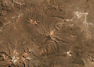
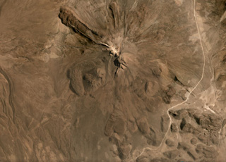
 The Pleistocene Patilla Pata complex is in the center of this Planet Labs satellite image monthly mosaic (N is at the top; this image is approximately 15 km across). The edifice is deeply glacially eroded with a remnant peak in the center. Volcán Larancagua is to the SW. As of the time of image acquisition, there is no evidence for Holocene activity.
Satellite image courtesy of Planet Labs Inc., 2019 (https://www.planet.com/).
 The Olca-Paruma volcanic complex, seen here from the west, forms a 15-km-long E-W ridge forming the border between Chile and Bolivia and is comprised of several stratovolcanoes with Holocene lava flows. Volcán Olca lies near the western end of the complex. It is flanked to the east by Volcán Paruma, which is immediately west of the higher pre-Holocene Cerro Paruma volcano, the conical peak in the background. Volcán Paruma has been the source of conspicuous fresh lava flows and has displayed persistent fumarolic activity in recent years.
 Photo by José Naranjo, 2001 (Servico Nacional de Geologica y Mineria).
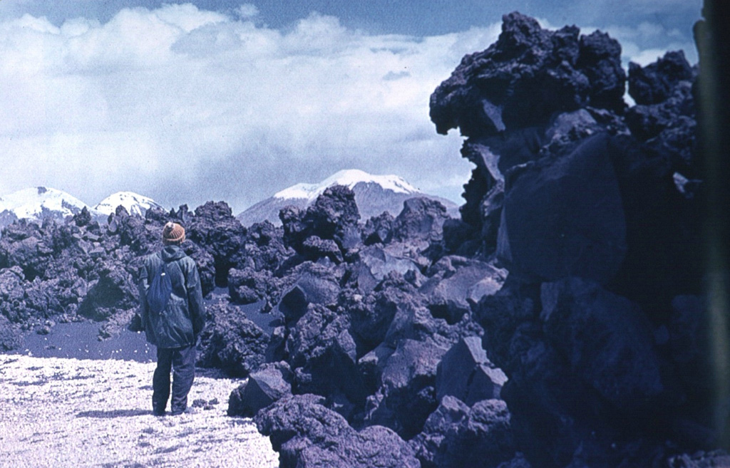
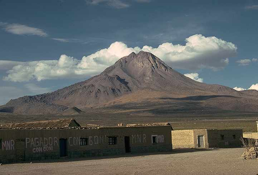
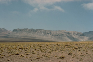
 Symmetrical Tata Sabaya stratovolcano towers to the north above the village of Pagador in the Altiplano of Bolivia. Thick dacitic lava flows at the left partially cover a scarp from a major collapse of the edifice that produced a large debris avalanche which swept into the Salar de Coipasa, covering an area of more than 300 km2 south of the volcano. The morphology of the volcano has been subsequently modified by dome emplacement (left and right) and hot avalanches.
Photo by Jon Davidson (University of Durham).
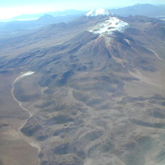
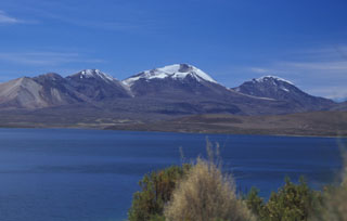
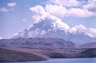
 Nevado del Sajama, rising to 6542 m about 20 km east of the Chilean border, is Bolivia's highest mountain. The steep-sided volcano is seen here from the Chilean side of the border, rising above Laguna Chungará, which was formed when a debris avalanche from Parinacota volcano (out of view to the left) blocked drainages. Sajama consists of an andesitic stratovolcano overlying andesitic-to-rhyodacitic lava domes. Pleistocene lava flows from Parinacota form the ridge at the left, and the flanks of Pleistocene Quisiquisini volcano rise to the right.
Photo by Lee Siebert, 2004 (Smithsonian Institution).
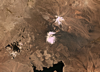
 Snow capped volcanoes dot this NASA International Space Station image (with north to the upper right) taken along the Chile-Bolivia border. The snow-capped peak at the far left-center is Guallatiri volcano, and to its right are the three peaks of Nevados Quimsachata, which includes Acotango volcano. The two peaks at the upper left are Pomerape and Parinacota, with Laguna Chungara below. Nevado del Sajama in Bolivia lies at the upper right-center. At the lower right is the snow-free volcano of Macizo de Larancagua.
NASA International Space Station image ISS009-E-6848, 2004 (http://eol.jsc.nasa.gov/).
 Snow-capped Licancabur volcano rises to the east beyond a Pliocene rhyolitic pyroclastic-flow deposit in the foreground from the Chaxas lava dome. Block lava flows from Licancabur have traveled as far as 12 km from the summit crater.
Photo courtesy of Oscar González-Ferrán (University of Chile).
 Several lava domes and flows or coulees of the Jatun Mundo Quri Warani complex (also known as Nuevo Mundo) in Bolivia are shown in this July 2019 Planet Labs satellite image monthly mosaic (N is at the top; this image is approximately 23 km across).
Satellite image courtesy of Planet Labs Inc., 2019 (https://www.planet.com/).
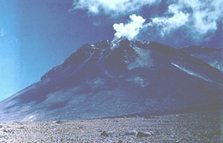
 Steam rises from the fumarolically active southern summit crater of Irruputuncu, a small stratovolcano that straddles the Chile/Bolivia border. Irruputuncu, seen here from the WSW, was constructed within the collapse scarp of a Holocene debris avalanche whose deposit extends to the SW. Levees of viscous lava flows down the western flank of an edifice that was constructed within this scarp are seen at the lower left. The first unambiguous historical eruption from Irruputuncu took place in November 1995.
Photo by José Naranjo, 2001 (Servico Nacional de Geologica y Mineria).
 The Pleistocene Nevado Anallajsi volcanic complex in Bolivia is in the center of this Planet Labs satellite image monthly mosaic (N is at the top; this image is approximately 47 km across). The flanks have been deeply eroded and a remnant peak is in the center. At the time of this image acquisition there is no evidence for Holocene activity.
Satellite image courtesy of Planet Labs Inc., 2019 (https://www.planet.com/).
 The Cerro la Torta lava dome formed on the western flank of Cerros de Tocorpuri around 34 ka, shown in this 5 November 2019 Sentinel-2 satellite image (N is at the top). The N-S length of the dome is 4 km with an areal extent of 12 km2, and a 4.7 km3 volume. The complex is located along the Chile-Bolivia border.
Satellite image courtesy of Copernicus Sentinel Data, 2019.
 The youthful-looking rhyolitic lava dome, Cerro la Torta (left of center), lies at its western foot of Cerros de Tocorpuri (or Volcán Tocorpuri), a stratovolcano complex on the Chile-Bolivia border. The circular, roughly 5 cu km Cerro la Torta has a flat-topped surface with wrinkled flow ridges and terminates in steep, talus-covered margins about 150 m high. The dome has a youthful appearance, but its age is not precisely known. Snow cover in this Landsat view is deep blue.
 NASA Landsat image, 1999 (courtesy of Hawaii Synergy Project, Univ. of Hawaii Institute of Geophysics & Planetology).
 The snow-speckled volcanic complex near the center of this NASA International Space Station image (with north to the lower right) is the Patilla Pata complex. The age of this volcano is uncertain, and Holocene activity has not been confirmed. This extensively eroded andesitic and basaltic volcano lies along a graben extending NE from glacier-covered Pomerape volcano at the upper right, which is part of the Nevados de Payachata complex that includes Parinacota volcano.
NASA International Space Station image ISS009-E-6839, 2004 (http://eol.jsc.nasa.gov/).
 The flanks of Tata Sabaya have largely formed through the extrusion of lava domes and flows, with some lobate flows displaying pressure ridges and levees seen in this September 2019 Planet Labs satellite image monthly mosaic (N is at the top; this image is approximately 12 km across). The NW end of a hummocky roughly 300 km2 debris avalanche deposit is in the lower right corner of this image. The collapse scarp from the flank collapse that produced the deposit and opened toward the S has been subsequently filled by lava domes.
Satellite image courtesy of Planet Labs Inc., 2019 (https://www.planet.com/).
 The eroded volcanic massif above and to the right of the center of this NASA International Space Station image (with north to the upper right) is the Nevado Anallajsi volcanic complex. The basaltic-to-dacitic volcano has been extensively dissected by glaciers. Younger basaltic lava flows were erupted from a north-flank vent, but the age of this activity is uncertain. The large volcano at the bottom center is Sajama volcano, also in Bolivia, and the twin snow-capped peaks at the far left-center are Pomerape and Parinacota volcanoes along the Chilean border.
NASA International Space Station image ISS009-E-6848, 2004 (http://eol.jsc.nasa.gov/).
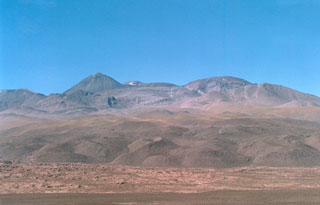
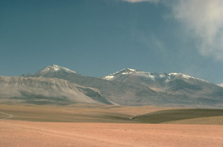
 Three N-S-trending volcanoes of the Quimsachata chain rise along the Chile-Bolivia border above the SW shore of Laguna Chungará. From left to right, they are 5730-m-high Volcán Humarata, 6052-m-high Volcán Acotango, and 5990-m-high Cerro Capurata volcanoes. No historical eruptions are known from the chain, but Acotango volcano has a youthful morphology with lava flows of inferred late-Pleistocene age. Its broad summit crater is open to the north and is the source of a large andesitic-dacitic lava flow.
 Photo by Lee Siebert, 2004 (Smithsonian Institution).
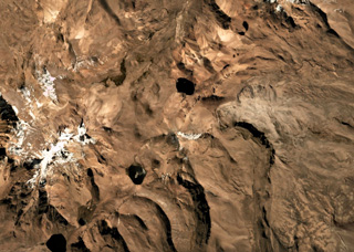
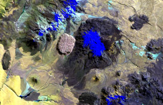
 The two maars of the Laguna Jayu Khota group in Bolivia are shown in this June 2019 Planet Labs satellite image monthly mosaic (N is at the top; this image is approximately 10 km across). The Laguna Jayu Khota maar is near the center of the image and the Nehke Khota maar is on the southern side of the road near the lower left corner.
Satellite image courtesy of Planet Labs Inc., 2019 (https://www.planet.com/).
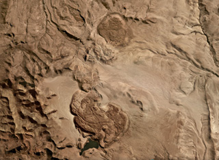
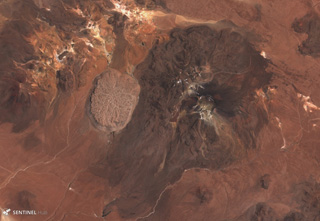
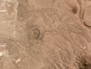
 Cerros de Guayaques is the irregular 10-km-long N-S chain down the center of this 5 November 2019 Sentinel-2 satellite image, along the Chile-Bolivia border. The group consists of lava domes, and a crater near the center of the complex produced a 5-km-long lava flow to the SW and W.
Satellite image courtesy of Copernicus Sentinel Data, 2019.
 Cerro Volcán Tambo Quemado is located in the Bolivian Altiplano and is in the center of this June 2019 Planet Labs satellite image monthly mosaic (N is at the top; this image is approximately 24 km across). Three overlapping craters form the complex, with a lava dome inside the youngest.
Satellite image courtesy of Planet Labs Inc., 2019 (https://www.planet.com/).
 The western side of the Sairecábur volcanic complex is seen with thick, blocky lava flows in the foreground. This chain of andesitic-dacitic volcanoes along the Chile-Bolivia border contains at least 10 postglacial centers and stretches from Escalante volcano on the north to Sairecábur volcano on the south. The highest peak, Sairecábur, is located on the northern margin of a 4.5-km-wide caldera. An active sulfur mine is located north of the volcano. Escalante has a crater lake at its summit and youthful lava flows on its flanks.
Photo by Raphaél Paris, 2004 (CNRS, Clermont-Ferrand).
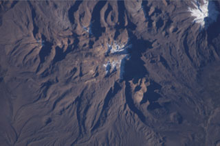
 Parinacota is the larger of the two main edifices in this November 2019 Planet Labs satellite image monthly mosaic (N is at the top; this image is approximately 23 km across). With Pomerape to the NE, together they form the Nevados de Payachata group along the Chile-Bolivia border. The group of lakes to the SW formed within a debris avalanche deposit about 8,000 years ago that is more than 22 km long with a volume of 6 km3. The current cone formed over the resulting scarp and older edifice, and has a summit crater around 650 m wide. Lava flows are visible on all flanks, with some flows emplaced around the debris avalanche deposit hummocks.
Satellite image courtesy of Planet Labs Inc., 2019 (https://www.planet.com/).
 The N-S-trending chain of andesitic-dacitic volcanoes along the Chile-Bolivia border just left of the center of this Landsat image is the Sairecábur-Escalante volcanic massif. Snow-covered areas are blue in this image of the chain, which contains at least 10 postglacial centers. A massive lava flow extends to the west, and a youthful flow traveled SE from Curinquinca volcano at the NE side of the chain. Laguna Verde is the left-hand lake at the bottom, NE of dark-colored Licancabur volcano; Juriques volcano to its right has a pronounced summit crater.
NASA Landsat image, 1999 (courtesy of Hawaii Synergy Project, Univ. of Hawaii Institute of Geophysics & Planetology).
 Sajama volcano in Bolivia towers beyond the Chilean border above Laguna Chungará. Blocky Pleistocene lava flows from Parinacota volcano, out of view to the left, extend across the middle of the photo. Sajama is Bolivia's highest peak and rises about 2000 m above its base. The dominantly andesitic volcano overlies andesitic-to-rhyolitic lava domes.
Photo by Oscar González-Ferrán (University of Chile).
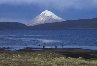
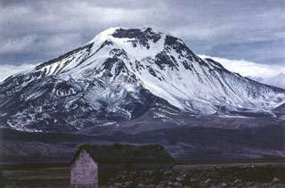
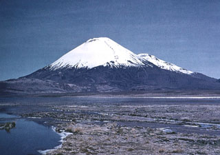
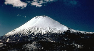 Symmetrical Volcán Parinacota rises north of Lake Chungará in the foreground. The lake was formed when collapse of an ancestral Parinacota edifice about 8000 years ago produced a massive 5-6 cu km debris avalanche that dammed a preexisting river. Subsequent eruptions of andesitic aa lava flows and andesitic pumice and scoria flows constructed the modern conical edifice, obscuring the avalanche source scarp. The summit of Parinacota volcano contains a pristine, 300-m-wide crater.
Photo by John Davidson, University of Michigan (courtesy of Hugo Moreno, University of Chile).
 Volcán Pomerape is the northernmost of twin stratovolcanoes forming the Nevados de Payachata along the Chile-Bolivia border. The 6282-m-high Pomerape lies across a saddle from Parinacota volcano, out of view to the right. The glacially dissected Pomerape was constructed above a base of dacitic-rhyolitic lava domes. The dominantly andesitic stratovolcano is capped by dacitic breccias and is of dominantly Pleistocene age.
Photo by Oscar González-Ferrán (University of Chile).
 Cerros de Tocorpuri, seen here from the west, is a Pleistocene stratovolcano complex on the Chile-Bolivia border. A Holocene lava dome on its western foot, Cerro la Torta, forms the light-colored ridge at the left foreground. The circular, roughly 5 cu km Cerro la Torta was erupted from a central vent and is surrounded by a flat-topped surface with wrinkled flow ridges. The flow terminates in steep, talus-covered margins about 150-m high. Lava extrusion was preceded by minor silicic explosive eruptions.
Copyrighted photo by Katia and Maurice Krafft, 1983.
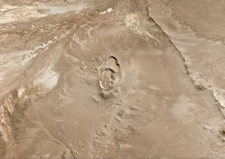
 The irregular 10-km-long N-S-trending chain just left of the center of this Landsat image is Cerros de Guayaques. These rhyodacitic lava domes straddle the Chile-Bolivia border. The 10-km-long chain is located immediately east of the Purico pyroclastic shield, part of which is visible on the left side of the image. A well-defined summit crater was the source of the largest lava flows, which form the lobate flows that extend 3 km to the SW. There are no records of historical activity from Guayaques volcano.
 NASA Landsat image, 1999 (courtesy of Hawaii Synergy Project, Univ. of Hawaii Institute of Geophysics & Planetology).
 Steam pours from vigorous fumaroles near the summit of Volcán Ollagüe. This massive 5868-m-high stratovolcano is capped by a large dacitic lava dome. Collapse of the volcano produced a massive Pleistocene debris-avalanche deposit that extends to the west. Active sulfur mines on the upper western and southern flanks are reached by a road that climbs to about 5500 m elevation. Only increased fumarolic activity has been recorded at Ollagüe during historical time.
Photo by Oscar González-Ferrán (University of Chile).
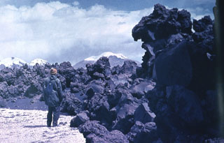
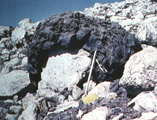 A dark-colored andesitic volcanic bomb, ejected in a plastic state with a ballistic trajectory, drapes older rhyolitic rocks. The bomb was ejected during the Ajata volcanic eruptions. Helium surface-exposure ages ranging between about 1385 and 6500 years ago were obtained from the three lava flows erupted from the Volcanes de Ajata. Note the ice axe for scale (right-center).
Photo by Oscar González-Ferrán (University of Chile).
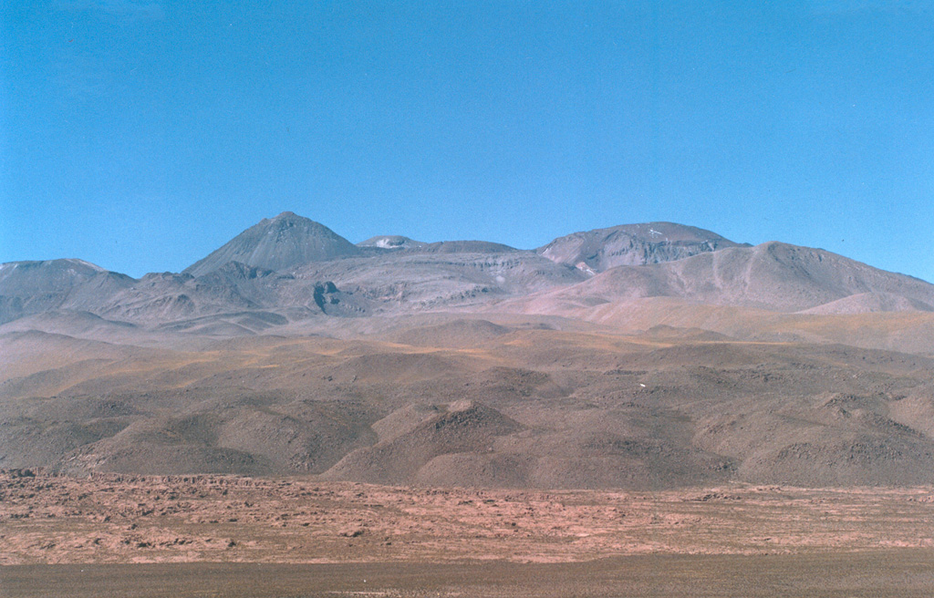
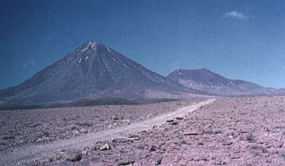
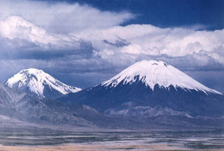 The Nevados de Payachata volcanic group in northern Chile, seen here from the west, consists of the symmetrical, 6348-m-high Parinacota volcano (right) and its older twin volcano, Pleistocene 6222-m-high Pomerape volcano (left). The young cone of Parinacota post-dates collapse of an older edifice about 8000 years ago. The most recent activity at Parinacota produced a series of fresh-looking lava flows from satellitic cones on the south and SW flanks.
 Photo by Oscar González-Ferrán (University of Chile).
 Volcán Linzor is located along on the Chile-Bolivia border about 60 km ESE of San Pedro-San Pablo volcano. Linzor is seen here from the refuge at Laguna Colorada, east of the volcano. The precise age of the latest eruption of this 5680-m-high stratovolcano is not known.
Photo by Raphaél Paris, 2004 (CNRS, Clermont-Ferrand).
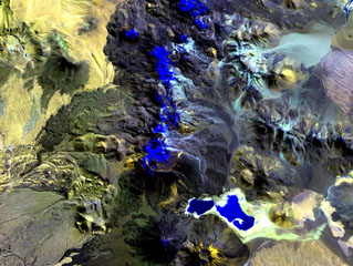
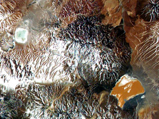 The large dark-colored area above orange-colored Laguna Colorada in this NASA International Space Station image (with north to the upper left) is Volcán de Jorcada. This elongated fissure-controlled volcanic massif contains more than 50 craters, small stratovolcanoes, and lava domes erupted along four fissures covering an area of 230 km2. Activity has migrated to the north, and the youngest fissure, on the NW side of the complex, produced a number of snow-dusted cones visible left of the center of this image.
NASA International Space Station image ISS005-E-8788, 2002 (http://eol.jsc.nasa.gov/).
 The southern side of conical, glacier-clad Parinacota volcano is seen from south of Laguna Changará, with its twin volcano, Pomerape, visible in the distance behind its right-hand flank. A complex of lighter colored dacitic-rhyolitic lava domes can be seen at the SW flank of Parinacota (middle left). The main cone of Parinacota was constructed during the Holocene primarily by the effusion of andesitic lava flows following collapse of an earlier edifice. The youngest of these flows was dated at between 1300 and 2000 years ago.
Photo by Oscar González-Ferrán (University of Chile).
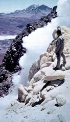
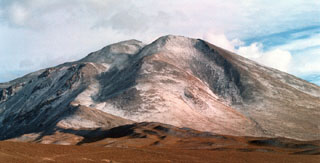
 Snow-capped Uturuncu, the highest peak of SW Bolivia, rises to 6008 m. Andesitic and dacitic lava flows dominate on Uturuncu, seen here from the south. Although andesitic and dacitic lava flows display well-preserved flow features, youthful-looking summit lava flows show evidence of glaciation. Two active sulfur-producing fumarole fields are located near the summit. Large-scale ground deformation observed beginning in May 1992, along with recently detected seismicity, indicates that a magmatic system is still present.
Photo by Steve Sparks, 2003 (University of Bristol).
 This viscous andesitic aa flow was erupted from the Volcanes de Ajata cinder cones along a N-S fracture on the southern flank of Parinacota. Helium-exposure ages of about 5985 and 6500 years ago were obtained from the lowermost and oldest of three lava flows of the Volcanes de Ajata. Snow-capped Acotango, Sajama, and Guallatiri volcanoes form the horizon to the east.
Photo by Oscar González-Ferrán (University of Chile).
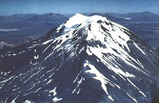
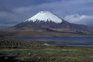 Glacier-clad Volcán Parinacota rises to the NE above Laguna Chungará near the Chile-Bolivia border. The lake was formed when collapse of Parinacota about 8000 years ago produced a 6 cu km debris avalanche that traveled 22 km to the west and blocked drainages. Subsequent eruptions constructed the 6348-m-high symmetrical stratovolcano, which towers above late-Pleistocene andesitic-to-rhyolitic lava domes and flows in the middle ground.
 Photo by Lee Siebert, 2004 (Smithsonian Institution).
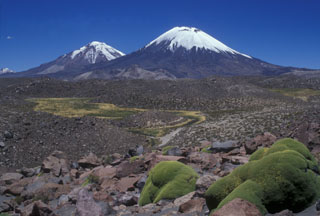 The Nevados de Payachata volcanic group, the scenic highlight of Lauca National Park, is seen here from the SW and consists of the symmetrical, 6348-m-high Parinacota volcano (right) and its older twin volcano, Pleistocene 6222-m-high Pomerape volcano (left). Collapse of Parinacota about 8000 years ago produced a 6 cu km debris avalanche that formed the hummocky terrain in the foreground, with the colorful Llareta plant at the lower right. Hummocks in this medial portion of the avalanche deposit are about 50-100 m high.
Photo by Lee Siebert, 2004 (Smithsonian Institution).
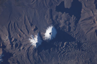 The two snow-capped volcanoes of the Nevados de Payachata volcanic group dominate this NASA International Space Station image (with north to the bottom). A prominent summit crater tops symmetrical Parinacota volcano, constructed to the SW of its eroded Pleistocene twin, Pomerape volcano. Silicic lava flows from Parinacota form lobes extending into Laguna Chungará, which was formed when a major debris avalanche from Parinacota blocked drainages. The hummocky debris-avalanche deposit covers much of the lower right part of the image.
NASA International Space Station image ISS009-E-6837, 2004 (http://eol.jsc.nasa.gov/).
 Glacier-capped Cerro Capurata lies at the southern end of the Nevados de Quimsachata volcano group. Quimsachata means "three" in the Andean Aymará language, and Capurata, along with 5730-m-high Humarata at the northern end of the chain and 6052-m-high Acotango in the center, straddles the Chile-Bolivia boundary along a roughly N-S line. The 6052-m-high Acotango stratovolcano is the central and highest of the three stratovolcanoes, each of which may have been active during the Holocene.
Photo by Sergio Kunstmann-Z (courtesy of Oscar González-Ferrán, University of Chile).
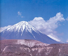
 The symmetrical, 5916-m-high Volcán Licancabur stratovolcano contains one of the world's highest lakes in its 400-m-wide summit crater. Archaeological ruins are located on the crater rim. Young lava flows with prominent levees extend up to 6 km down the NW-to-SW flanks. Most of the morphologically youthful volcano was constructed during the Holocene. The pre-Holocene Juriques volcano is located immediately to the SE and is capped by a 1.5-km-wide summit crater.
 Copyrighted photo by Katia and Maurice Krafft, 1983.
This is a compilation of Bolivia volcano information sources, such as official monitoring or other government agencies.
| Volcanic Ash Advisory Center | |
|---|---|
| Buenos Aires Volcanic Ash Advisory Center (VAAC) | |
| - Buenos Aires VAAC Archive | |